Pages

Friday, July 31, 2015

Yellowstone

Executive summary by darmansjah

Yellowstone is home to more geothermal features than any place on Earth.

LIVING COLOR

Colorful, pigmented bacteria rings Yellowstone’s Grand Prismatic Spring, the country’s largest hot spring. The sterile water in the center is a simmering 160F (71C).

ANIMAL AND MINERAL

Wolves, such as this male calling his pups roams Yellowstone in 11 overlapping packs. Mineral terraces form from dissolved limestone that rises through hot springs, solidifying when the water hits the open air.

Wyoming, Idaho, and Montana. The world’s first national park-established in 1872-preserves the continent’s largest supervolcano, the active Yellowstone caldera. Within Yellowstone National Park’s 3,572 square miles (8,992 sq km) of stunning  scenery are at least half of the world’s geothermal features, including more than 300 geysers an more than 10,000 hot springs, fumaroles, and mudpots. The park holds the largest concentration of mammals in the lower 48 states, with grizzly and black bears, gray wolves (restored in 1995), bison, elk, wolverines, and mountain lions. The Old Faithful geyser erupts 17 times a day, propelling thousands of gallons of steaming, pressurized water about 130 feet (40 m) into the air to the oohs, aahs, and gasps of visitors.

Thursday, July 30, 2015

Altiplano

Executive summary by darmansjah

A landscape of ice, fire, wind and salt stretching 600 miles (965 km)

BOLIVIA, PERU, AND ARGENTINA rich in silver, salt, and eerie appeal, the altiplano holds a mirror to the sky. The 12,000-foot-high (3,660 m) plateau stretches 600 miles (965 km) through the Andes of Bolivia, Peru, and Argentina, one of Earth’s largest tablelands. The water basins that once covered it have evaporated, but it still holds Titicaca, the world’s highest navigable lake. Bolivia’s capital, La Paz, is in the wetter north. The dry, lonely south includes Salar de Uyuni, an other worldly saltscape; laguna Colorada,  a salty, reddish lake favored by flamingos; and the sulfurous mudpots of Sol de Manana. There’s silver and tin beneath the surface, but few trees survive in the wind-sheared expanses and few crops can be coaxed from the Ground.

BLUE HORIZONS

A herd of domesticated Ilamas stands out in relief on the flat, spring-fed pastures of the Altiplano, Llamas and alpacas are native to the high, windswept region.

FINE FEATHERED FAMILIES

Reflected in Laguna colorada’s quiet waters, puna (or James’s) flamingos tend their less colorful young. The unusual birds are found only on high Andean plateau.

Wednesday, July 29, 2015

FROZEN ASSETS


Executive summary by darmansjah

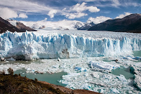
WATER Over 98 percent of the world’s fresh water is found in glaciers and ice caps.

Ice crumbling from the edges of the Perito Moreno glacier does little to reduce the size of Patagonia’s Southern Ice Field, the third largest glacial expanse in the world.


A glacier is a persistent body of dense ice exceeding a surface area of 0.1 km² constantly moving under its own gravity; it forms where the accumulation of snow exceeds its ablation (melting and sublimation) over many years, often centuries. Glaciers slowly deform and flow due to stresses induced by their weight, creating crevasses, seracs, and other distinguishing features. They also abrade rock and debris from their substrate to create landforms such as cirques and moraines. Glaciers form only on land and are distinct from the much thinner sea ice and lake ice that form on the surface of bodies of water.

On Earth, 99% of glacial ice is contained within vast ice sheets in the polar regions, but glaciers may be found in mountain ranges on every continent, and on a few high-latitude oceanic islands. Between 35°N and 35°S, glaciers occur only in the Himalayas, Andes, a few high mountains in East Africa, Mexico, New Guinea and on Zard Kuh in Iran.

Glacial ice is the largest reservoir of freshwater on Earth.Many glaciers from temperate, alpine and seasonal polar climates store water as ice during the colder seasons and release it later in the form of meltwater as warmer summer temperatures cause the glacier to melt, creating a water source that is especially important for plants, animals and human uses when other sources may be scant. Within high altitude and Antarctic environments, the seasonal temperature difference is often not sufficient to release meltwater.

Because glacial mass is affected by long-term climate changes, e.g., precipitation, mean temperature, and cloud cover, glacial mass changes are considered among the most sensitive indicators of climate change and are a major source of variations in sea level.
 

Monday, July 27, 2015

Tongariro National Park

Executive summary by darmansjah

Tongariro National Park is the oldest national park in New Zealand, located in the central North Island. It has been acknowledged by UNESCO as one of the 28 mixed cultural and natural World Heritage Sites.
Tongariro National Park was the fourth national park established in the world.The active volcanic mountains Ruapehu, Ngauruhoe, and Tongariro are located in the centre of the park.

There are a number of Māori religious sites within the park and the summits of Tongariro, including Ngauruhoe and Ruapehu, are tapu (sacred). The park includes many towns around its boundary including Ohakune, Waiouru, Horopito, Pokaka, Erua, National Park Village, Whakapapa skifield and Turangi.